Urban vegetation: the case for green cities
Providing more green spaces to city dwellers, yes, but where do we start? New technologies applied to GIS may hold the key.
Yann Daoulas
Vegetation in the city is often thought of as that of public spaces: parks, flower beds, rows of trees. However, much of the urban vegetation is to be found in private spaces. Delimitation hedges, shrubs, fruit trees, private properties are full of plants that are not included in the inventories due to a lack of data. However, tools exist to assess the entire vegetal population of an area and monitor its development.
In 2020, according to public statistics institute INSEE, France had 53 million city dwellers, or more than 75% of the population. This figure could be revised downwards in the coming years. Indeed, while living in the city offers many advantages, urban life can also prove to be a source of stress and generate health problems. City dwellers are increasingly fleeing urban centers to find a new balance in the countryside, in a calmer and healthier environment. Health risks, discomfort in hot weather and the recent health crisis are only accelerating this urban exodus. Large conurbations must adapt and define the characteristics of the city of tomorrow. Their challenge is to guarantee a pleasant quality of life for city dwellers by protecting the surrounding biodiversity. To breathe new life into our cities, it is now crucial to find ways to make our urban environments greener, and in a smarter fashion.
The city, a sensitive artificialized space
Cities are more often than not concrete jungles: roads, infrastructures, industrial zones and homes often leave little room for vegetation. This hard-landscaping trend poses various problems, not least the increase in volumes of runoff water. Which directly leads to higher flooding risks, while impeding water infiltration and increasing the dispersion and concentration of polluting particles. These spaces are often covered in porous material with dark colors. This implies a low albedo, ie. the ratio of reflected light to incident light. In other words, these surfaces store energy in daytime and release it in the form of heat at night. This contributes to the rise in ground and air temperatures : they remain high in night time, slowing the cooling of the city. These heat islands create significant temperature differences between the city center and the outskirts, inconveniencing all of its residents.
The architecture of cities, especially building height and street configuration, plays a role in hindering air circulation, creating hot masses of air. In addition, urban density and the concentration of transport contribute to the increase in pollution and its condensation, which in turn increases the heat effect.
The lack of vegetation in the city has many consequences harmful both to people and biodiversity. From an ecological and public health point of view, the need to modify our cities by integrating current climatic, economic and societal challenges now comes as an evidence.
Greening our cities : what for ?
Milder climate
How does the vegetation cover affect the urban climate? Why is it less hot under a tree than under a sunshade ? Several phenomena participate in local climate cooling. First, the shadow cast by trees attenuates the passage of solar radiation, which lowers surface temperatures, and also those of buildings. Trees, when properly positioned, can improve frame insulation, thus reducing energy consumption. Developing vegetation absorbs part of the incident light to transform it into energy, while reflecting the remainder. Depending on the varieties present, a forest can reflect up to 20% of the incident light.
Another phenomenon is evapotranspiration. This word refers to the process by which the atmosphere receives water from plant transpiration and soil evaporation. Latent heat of vaporization is the amount of heat required to transform a material from liquid to gas. Depending on the temperature of the material – in this case, water – the latent heat varies. The hotter the water, the faster the process. As it evaporates, water moistens the air and cools the atmosphere. This phenomenon is typically observed in large forests where water evaporation is so strong that volumes of water appear in the form of vapor called “flying rivers”. As true natural air conditioners, trees thus have the ability to reduce the phenomenon of urban of heat islands.
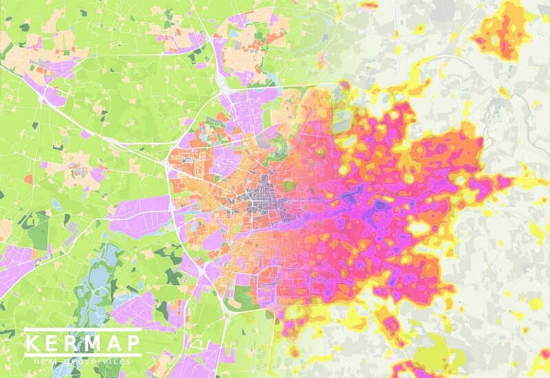
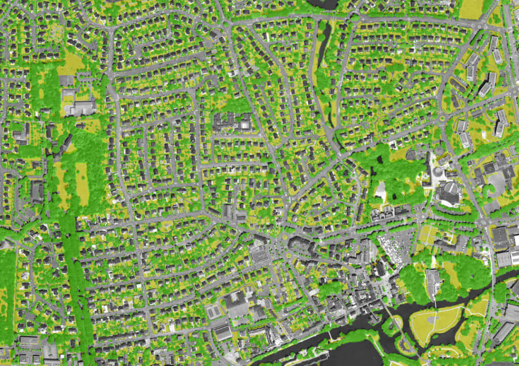
To the left: vegetation map drawn from land use analysis. To the right: thermography based on satellite imagery. This approach helps locate urban heat and cool islands at city or district level and understand where they come from.
Air you can breathe
During photosynthesis, trees absorb CO2, one of the main greenhouse gases, and release the oxygen, or O2, needed by our bodies. Trees are also excellent filters against exhaust emissions from motor engines, such as fine particles and nitrogen oxides. These particles are health risk factors, in particular for lung and cardiovascular diseases.
However, while leaves pick up particles, they also release some. Trees indeed let off volatile organic compounds (VOCs) including hydrocarbons such as isoprene. Under the rays of the sun, and when in contact with nitrogen oxides in the atmosphere, isoprene turns into ozone. A crucial element in the stratosphere to protect against harmful ultraviolet rays, it becomes a pollutant when in the lower layers of the atmosphere (troposphere), causing respiratory discomfort and irritation. One sould thus be careful with the choice and location of the different varieties.
Through the soil, trees can also filter urban and agricultural pollutants. For example, hedges and embankments, the main elements of the bocage landscape, are made up of plants which absorb and filter pollutants through their roots, thus preventing their propagation in water.
Protecting biodiversity
A tree is a biotope. It is an environment with homogeneous biological properties that is home to different species: animals, plants, fungi and microorganisms. Its role is fundamental in the fight against the extinction of species. Global warming, the destruction of the living environment and pollution are among the main factors behind the disappearance of species. The importance of trees is no longer to be proven in the fight against climate change. They harbor life, nesting and food supply, while offering protection to many species. Even when it’s dead, a tree continues to support insects and shelter animals such as night owls.
A new way of living in the city
Air purification, improved water quality, natural air conditioners: forests do have impacts on our physical health. And trees continue to surprise us … Have you ever felt a sense of tranquility, of appeasement during a walk in the forest? Probably. This phenomenon is said to have a scientific explanation. Indeed, trees also release phytoncides. Japan-born sylvotherapy, or tree therapy, promotes the virtues of these molecules, believed to reduce stress and improve our immune defenses. Although still controversial, this therapeutic approach is booming in Europe. What is certain is that these relaxation and walking areas offer regeneration and moments of serenity in a life that is sometimes too hectic.
Finding the right place for trees in the city: Emmanuel Bouriau’s take
How far can technology help in the planning of urban developments? This is one of the questions investigated by Emmanuel Bouriau, head of the environment and digital units at Rennes Métropole’s Urban planning and Intercommunal Development Agency (AUDIAR).
Kermap has been working since 2018 with Rennes Metropole and, indirectly, with AUDIAR. Kermap produced very-high-resolution a vegetation map in the city and suburbs, differentiating three classes : tree, shrubby and herbaceous. The maps were carried out from orthophotographs and a photogrammetric reconstruction so as to identify plant height.
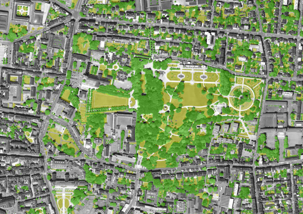
These documents provide a thorough knowledge of the area’s vegetation and its evolution over 3 years. They are complemented by a perceived vegetation index, ie. an objective ratio of the vegetation seen by a passer-by walking in any street of Rennes. Its utility is twofold : not only getting information on how inhabitants physically perceive the greening of a district or a street, but also better understanding the expectations of the citizens.
For Emmanuel Bouriau, the potential of Geographic Information Services (GIS) is ever growing, multiplying the possibilities for analysis. Data gathered by Audiar is processed and enriched in-house. Measurement tools and ratios are created in order to compare municipalities with each other. It is also “a way of interacting with the metropolitan authority and nurturing town planning”. As a matter of fact, such data can be used to monitor compliance to Urban Planning rules, to implement industry-specific policies, or even lead to climate-oriented studies on the canopy. Far from being short-sighted, the data can be used in a variety of fields and adjust to territorial specificities to produce custom, large-scale diagnostics.
The future of urban planning in Rennes : what to expect?
First, that nature in the city and biodiversity be better taken into account. A perfect illustration of that approach are the Prairies Saint Martin, where a genuine natural park emerged in the heart of the city. However, Mr. Bouriau specifies, this evolution will require time to unfold, with public and private forces working hand in hand. There is no way to control what private actors do, what will become of their estates. Building the cities of tomorrow will take time, to redevelop infrastructure, review our lifestyles and achieve acceptance of these changes.
Documenting and quantifying vegetation on a fine scale: yes we can! We provide you with the indicators you need to guide your green governance, let’s talk about it!