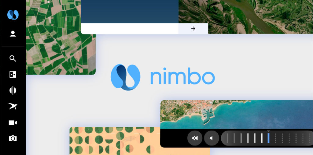
Kermap’s new Nimbo solution opens satellite data for all
Nimbo launches a new era for access to geospatial information. The solution is now available for professional applications, ahead of a consumer version.
Yann Daoulas
Earth observation data is abundant but its acquisition and use remain very challenging. Rennes, France-based company Kermap unveils a game-changer with the launch of Nimbo, an innovative turnkey solution facilitating access to geospatial intelligence. For the first time, public authorities and businesses can easily access strategic information that is at once recent, exclusive and affordable, thanks to the automated extraction of satellite data, updated on a monthly basis.

Vegetation, soil, climate, land use… A wealth of indicators are now immediately at hand to meet the needs of professionals, providing novel insights and informing their decision-making. Depending on their needs, data is directly integrated into their workflow applications thanks to the Nimbo API, or delivered into a custom Nimbo platform.
A breakthrough for geographic information
Nimbo uses an innovative artificial intelligence mode to take professional geospatial information to another level, by granting easy access to satellite data that is at once :
- Quick – automated data extraction upon satellite imagery acquisition
- Dynamic – fine monitoring of evolutions through monthly data updates
- Scalable – coverage of large areas, up to the continental level
- Reliable – statistically controlled data (see our use case on agriculture below)
- Agile – Nimbo quickly adjusts to customer issues worldwide, regardless of terrain
- Smooth – immediately available information through Nimbo API integration
This new solution epitomizes the firm belief fueling innovation at Kermap since its creation in 2017: satellite data should be put into everyone’s reach. Supporting this aim, an expertise and savoir-faire developed, that are now commended by its many clients and partners from the public and private sectors. Kermap has also garnered support from major institutional partners like France’s National Geographic Institute IGN and National Centre for Space Studies CNES, as well as the European Space Agency (ESA), whose “Aspire with ESA” programme helped accelerate the development of Nimbo.
The French start-up today takes the next step of this driving ambition with the commercial launch of Nimbo. This new product will help Kermap meet the ever-increasing demand for geospatial information, from all fields where natural, climate or land-use dynamics data is key: agriculture, environment, land planning, construction and civil engineering, exploration, insurance…
For all Earth observers too
A version of Nimbo is also coming out soon, in the guise of a geobrowsing platform for the general public. A new way of observing the Earth will be proposed, as the interface will let everyone explore monthly series of cloud-free satellite images. There, our planet’s evolutions will unveil through user-friendly observation and exploration features.
The re-creation of these images, using pictures from the Copernicus programme’s Sentinel mission, was yet another challenge. The experience and cutting-edge skills of Kermap’s teams have taken it up, to produce an innovative,100% made in France Earth observation platform, to be released shortly.
Nimbo premiere on farming data demonstrates its efficiency
Exclusive, large-scale, reliable information in record time. As an evidence of Nimbo’s robustness, Kermap releases the first 2020 map of dominant crops in 11 continental Europe countries. This data was automatically generated through deep-learning processes applied to satellite imagery. It involved the analysis of 20,000 Sentinel-2 time series images provided by the Copernicus programme, an initiative headed by the European Commission (EC), in partnership with the European Space Agency (ESA).
To date, this map is the only available data source on the past year’s agricultural surfaces at country and sub-country level (départements, regions and provinces). This information can be accessed freely online on agri.nimbo.earth
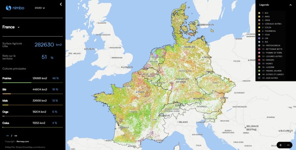
This version of the Nimbo mapping platform lets users browse the area covering the 11 countries under study, specifying each and every plot’s crop. Parallel to this geographic approach, statistics are generated to provide additional information on national and sub-national farming trends. A simple click will unveil the percentage of agricultural land in a given area, as well as its top 5 crop coverage.
Along the production of this European crop inventory, a verification process was conducted to ascertain the relevance of the Nimbo model for agriculture:
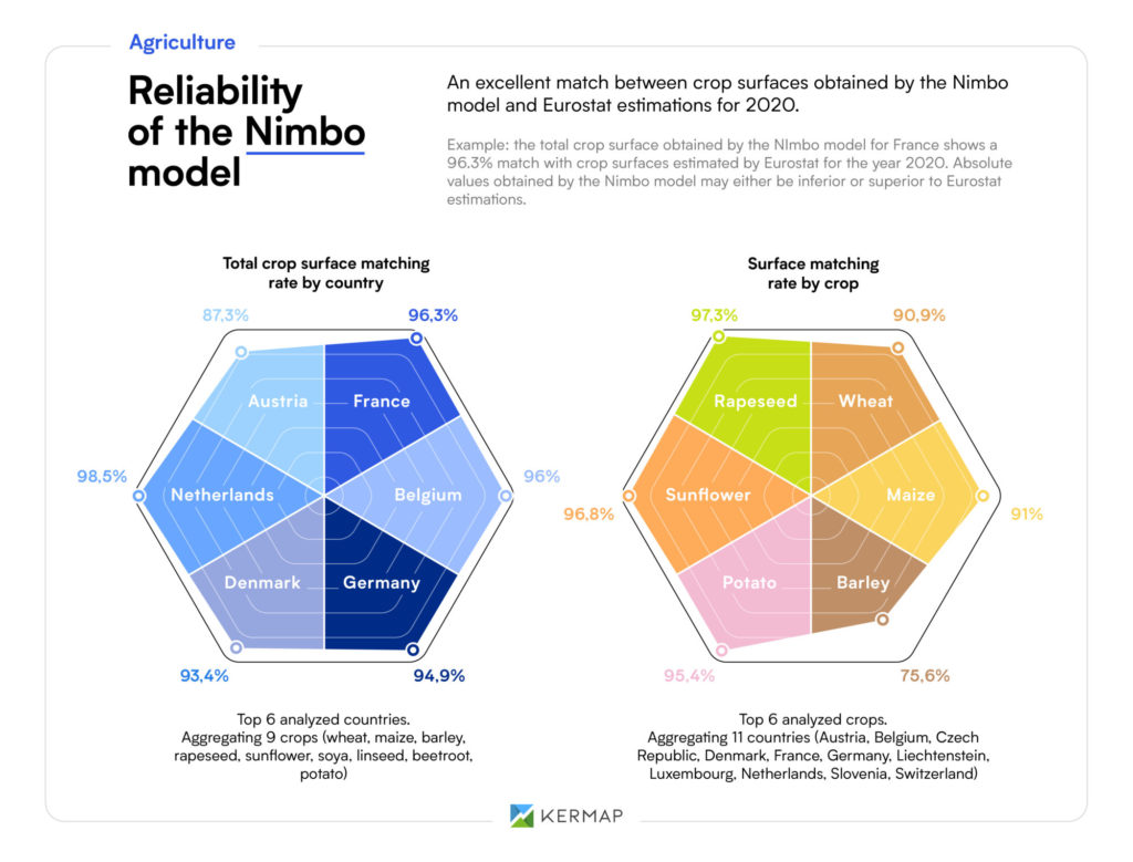
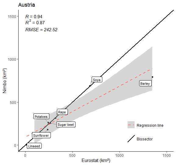
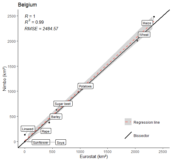
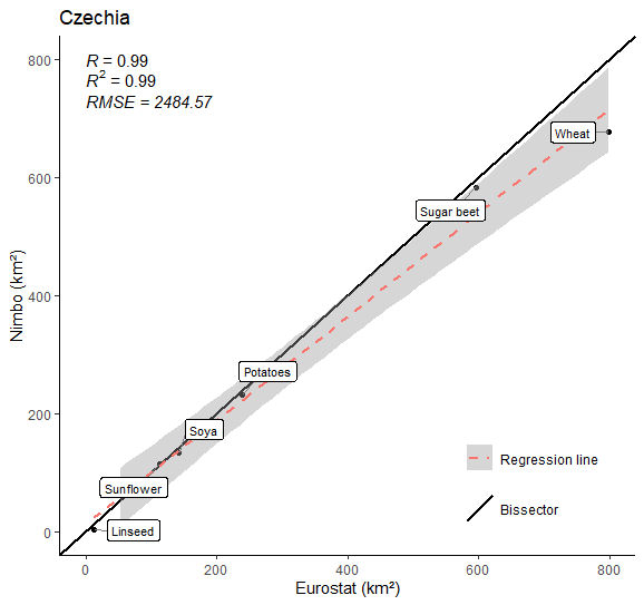
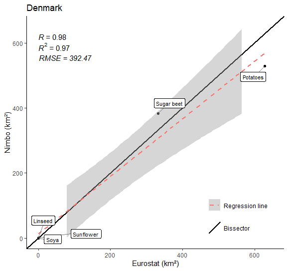
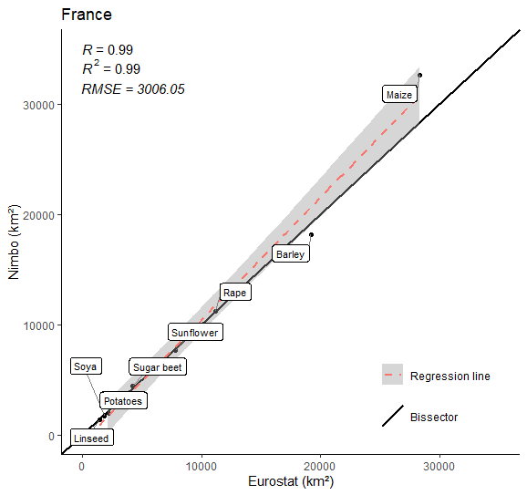
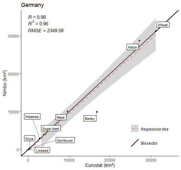
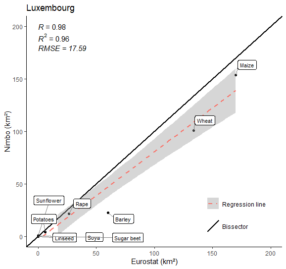
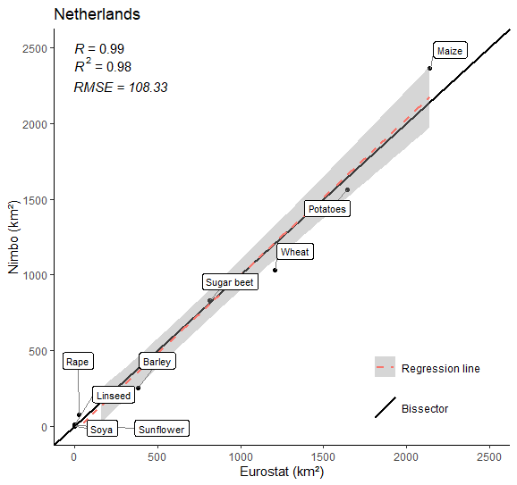
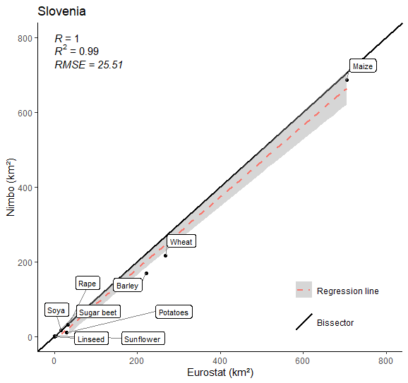
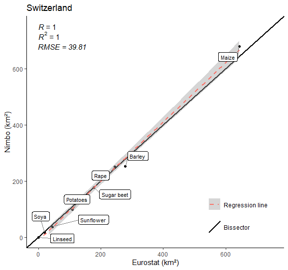
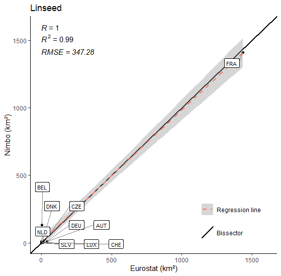
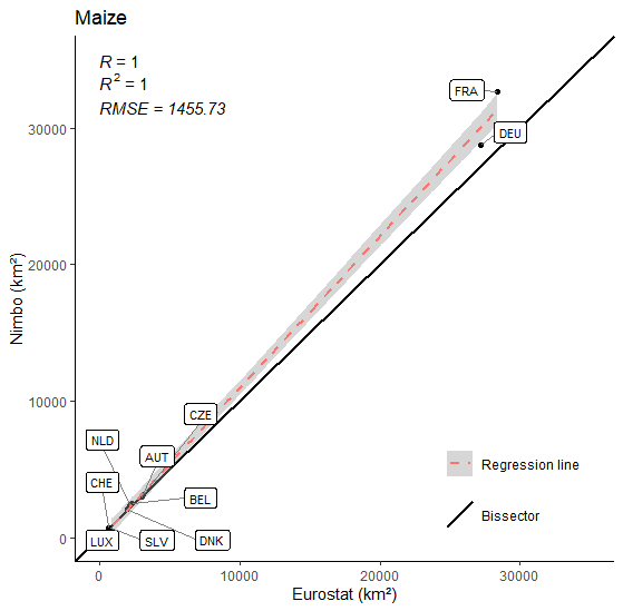
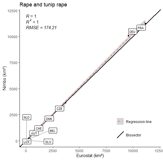
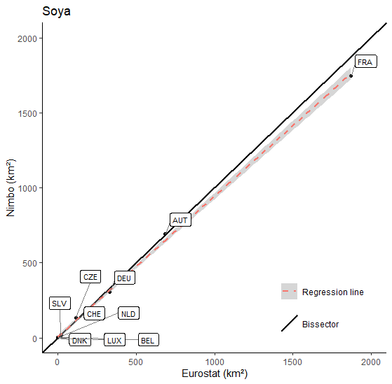
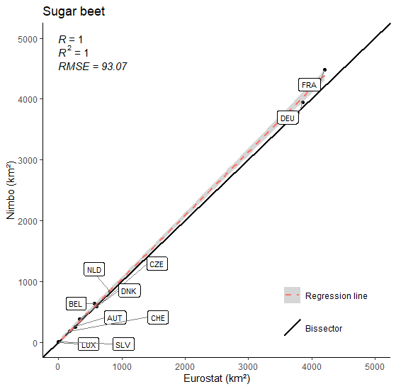
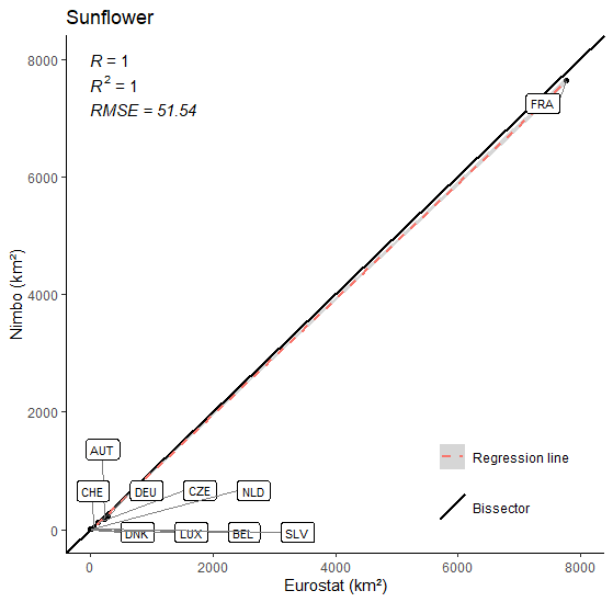
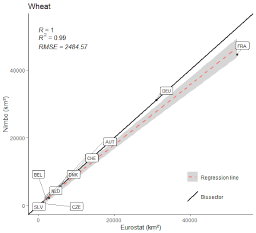
Surfaces calculated at national level for 2020 were checked against past year’s data as published by Eurostat. Nimbo’s performance compared very favorably with official figures, proving its high degree of reliability. Its results, based on objective Earth observation, almost systematically returned à 90 to 100% match with Eurostat estimations (which are extrapolated from self-reported data).
Making this whole dataset available so fast following the 2020 crop season, at various scales and in a reliable fashion, is unquestionably a first. This breakthrough is but one example of Nimbo’s ability to accelerate and amplify the flow of information across the agricultural sector, now more than ever in need of novel data to take up the environmental challenge.
Ask us all you want to know about Nimbo!
Appendix: Nimbo farming data controlled statistically
Crop areas calculated by Nimbo against Eurostat data for year 2020, by crop :
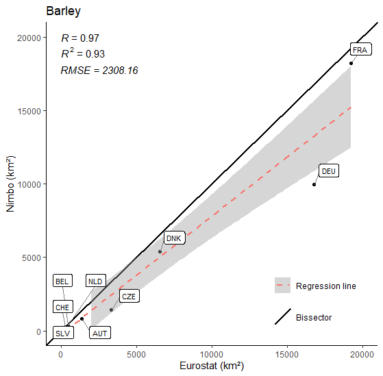

Crop farming areas calculated by Nimbo against Eurostat data for year 2020, by country :