Satellite imagery and climate change : monitoring the impact of drought in Iraq
On the occasion of the United Nations' World day to combat desertification and drought (17 June), Kermap’s Earth observation platform Nimbo Maps helps putting images and figures on Iraq’s critical situation
Yann Daoulas
The “land between two rivers” appears on the brink of desertification as extreme heat episodes induced by climate change exacerbate drought, itself linked to years of armed conflicts, cross-border water wars and a legacy of resource mismanagement. The whole country has been reeling under heat and failed rains during the past two years, leading to massive land transformations which can be observed from space. The extent of this degradation is made strikingly visible on Nimbo Maps, the chronological Earth observation platform published by Kermap, using Sentinel imagery from the European Union’s Copernicus programme.
👉 All views in this article come from the Nimbo Maps platform, based on Sentinel imagery from the Copernicus program (2020-2022)
The accelerated disappearance of water poses a threat to populations, the environment, biodiversity. From Iraqi Kurdistan to the Mesopotomian marshes, through the heart of the country nestled between the Tigris and the Euphrates rivers, no region is spared by a water crisis that might translate into another tragedy for Iraq in the short to mid-term. On the occasion of the United Nations’ World day to combat desertification and drought (17 June), Earth observations provides stunning insights into the ordeal that the country is going through.
Vanishing Lakes in Irak
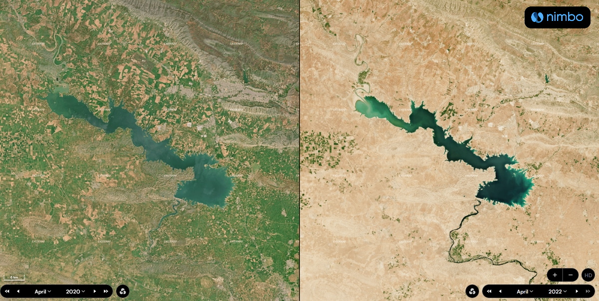
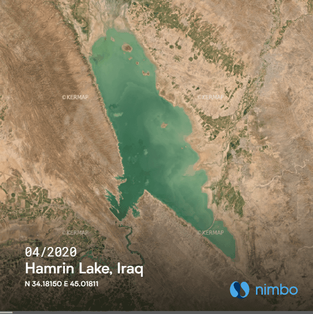
Vast bodies of water drying up, or short of. This is what has just happened to Lake Hamrin (above), located northeast of Baghdad. This artificial reservoir originally expanded over 340 sq. km. and contained 2 million cubic meters of water. Almost none of it was left in April 2022. Local authorities had long been warning against such an outcome, which they claimed was caused by their Iranian neighbors having dammed and diverted the Alwand river on the other side of the border.
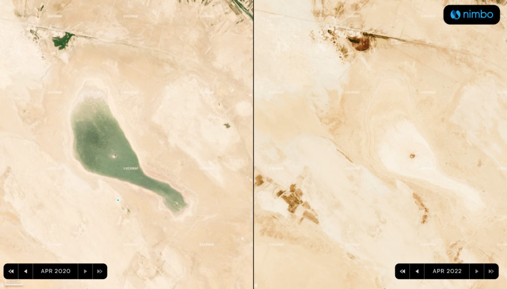
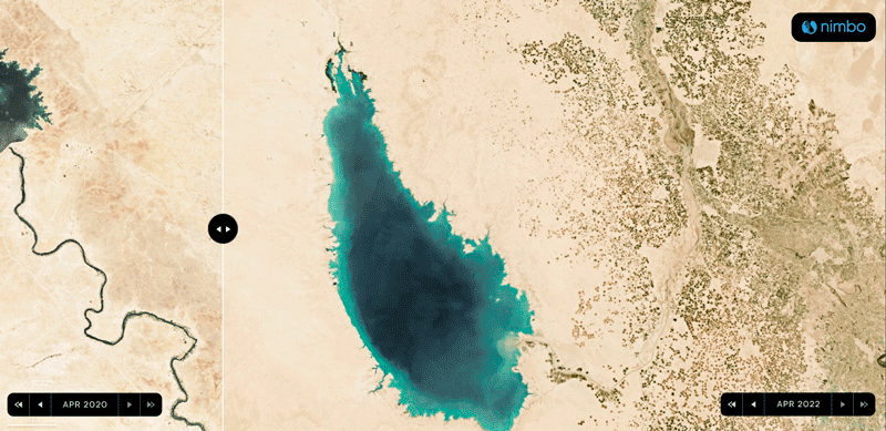
Halfway between Najaf and Nassiriyah, the much smaller Sawa Lake has met the same fate. In this once magnificent salty body of water dubbed “The Pearl of the South”, there was not a drop a left in April 2022. Climate change-induced heat as well as overuse for farming purposes have contributed to this drying up – and possibly also shifts in underground aquifers that streamed into the lake, caused by seismic events.
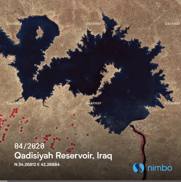
In other lakes and reservoirs across the country, water has not totally disappeared. But it has sharply receded almost everywhere. Earth observation points to notable decreases in bodies west of the Tikrit-Bagdad-Nadjaf line, as illustrated by the Qadisiyah Reservoir (below in infrared view) or the vast Thartar Reservoir, which has lost about 30% of its area since April 2020. There again, recent climatic developments come as the last straw, in another water war situation: this time Iraqi authorities lay blame on Turkey and its dam-building policy upstream of the Euphrates river.
In April 2022, the overall area covered by bodies of water in Iraq was down by 50% compared with April 2020, to about 3,500 sq. km, according to Kermap’s calculations, based on optical and radar images available in Nimbo Maps. A staggering drop that has to be put in perspective however, as bodies of water had amply refilled in spring 2020 following a very wet winter. Still, this evolution is remarkable both in pace – most of the decrease (-40%) occurred in the 12 months to April 2022 – and in intensity. This 3,500 sq. km. figure for surface water areas indeed marks a 40-year low, previous research by the Reach Initiative suggests.
Dying marshes
Farther south near the Persian Gulf, a millenary gem appears under imminent threat : the Mesopotamian Marshes. April 2022 imagery available in Nimbo Maps bears witness to the extent of the desolation : from these once vast, fertile wetlands expanding from the Nasiriyah region all the way to the Iranian border, there appears to be almost nothing left.
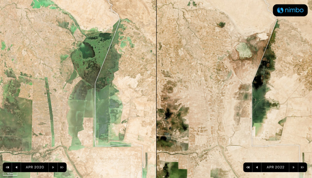
Since the 1960s, the story of the area has been that of a slow agony – abundantly documented by the CEOBS (Conflict and Environment Observatory). It was brought about by successive plagues : 90% of these marshlands have already been lost to oil exploitation, war, extensive farming, punitive water diversions and pollution. Climate change and inroads by sea water from the Persian Gulf are the latest calamities that could mean the definitive end of this unique, lush ecosystem, and of the population and culture which the Marshes have been home to for centuries.
Iraqi agriculture in tatters
2022 is on its way to be at least as hot and dry as 2021 and is already slated to be yet another catastrophic year for the country’s farming sector. For the second straight year, drought and water shortage has led the authorities to impose limits on irrigation and surfaces to be cultivated. These state controls mean, for instance, little or no production of amber rice, a staple from the Najaf area requiring permanent water coverage during summer months.
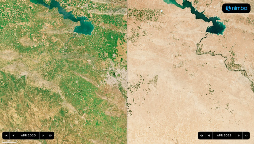
Meanwhile in the north, partly covered by Iraqi Kurdistan, on what little areas farmers are allowed to plant, cereals won’t grow, as conditions remain mercilessly dry. On images available in Nimbo Maps, the visual gap is staggering between April 2022 and April 2020 – keeping in mind that the latter was helped by favorable winter 2019 conditions beforehand :
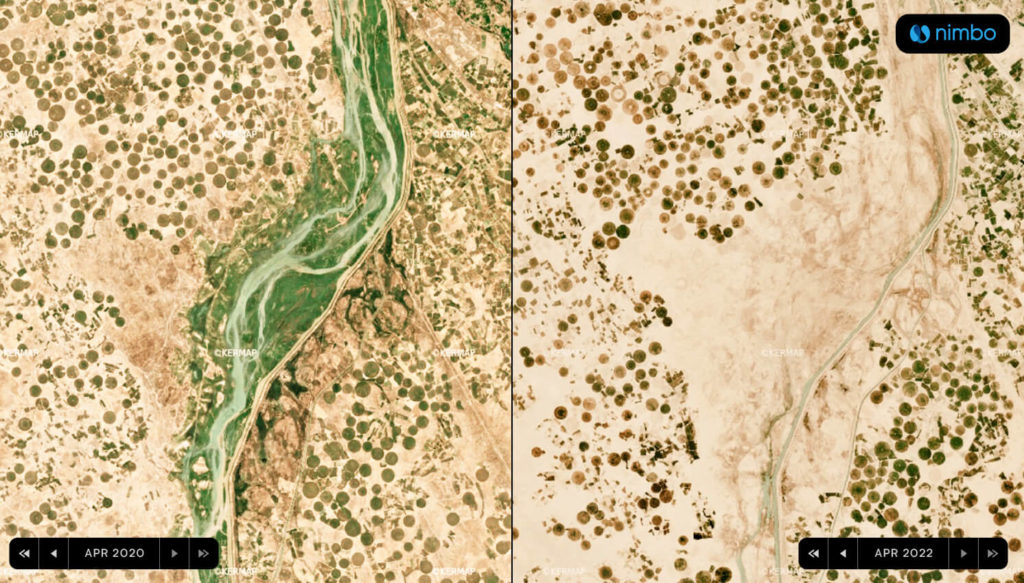
Overall, areas of irrigated crops in April 2022 were down 50% compared with April 2020 at 11,000 sq. km., and even four times smaller than they were in April 2019, calculations based on chlorophyll content mapping (NDVI) available in Nimbo Maps suggest. Despite a slight uptick from 2021 figures, the current situation remains alarming for farmers – many of them looking at a season without income – and for the whole Iraqi population in the midst of severe tensions on food commodity markets.
Beyond agriculture, NDVI estimations show that Iraq’s total area of vegetation-covered land has collapsed to 52,000 sq. km. in April 2022, from 100,000 sq. km. in April 2020 and 138,000 sq.km. in April 2019. In other words, during the past three years, Iraq has lost two-thirds of its vegetation area. This is also equivalent to 20% of the country’s total area, or the area of a country as big as Austria, now threatened by desertification as climate change effects sink in in the region.